The increasingly intense and unpredictable impacts of climate change demand that we embrace more change into our built environments. Though it sounds like an impossible task, precedents of cities, regions and countries doing so exist. Take the San Francisco Bay. Situated directly on the ‘ring of fire’ – a region around the basin of the Pacific Ocean characterized by high tectonic activity – the area is prone to earthquakes. Those of us who call the Bay home live with the knowledge that the next big one could happen at any time.
That awareness is the basis for how we’ve learned how to better negotiate earthquakes when they come. The effects of the two most devastating earthquakes to the region in the last century -- the 1906 San Francisco and 1989 Loma Prieta earthquakes – are proof of how far we've come. While the 1906 event effectively destroyed the city, the 1989 earthquake caused damage in ways that allowed daily life to continue relatively undisturbed.
Much of the devastation caused in 1906 resulted not from the quake itself but from the fires that raged in its aftermath. The earthquake struck in the early morning of April 18th in 1906, lasting for over a minute and clocking in at 7.8 on the Richter scale. In addition to felling structures – most of which were constructed purely out of wood at the time -- across the city, the quake ruptured gas mains, which quickly set houses ablaze. 250,000 buildings in total were destroyed. Almost 300,000 were left homeless, out of a total population of 410,000. Refugee tent camps sprang up from the Golden Gate Park to the Presidio, some of which were still in use two years after the event. As Jack London wrote at the time, “Not in history has a modern imperial city been so completely destroyed…. Nothing remains of it but memories.”
The Loma Prieta earthquake of 1989 was a different story. Part of that had to do with differences in magnitude and duration – Loma Prieta lasted for just 15 seconds and was 6.9 on the Richter magnitude scale. While written accounts describe the 1906 quake as "being in a dreadful nightmare," I remember the 1989 event as a strange rollercoaster. I was three at the time, in the living room of my parents’ house in Berkeley. Even at that young age, I had been trained to take cover when the ground started to shake so I crawled underneath my mother’s desk in the corner. A lamp on the adjacent bookshelf began to rock and I watched in wonder how it shook without anyone touching it, until it fell on the floor and shattered.
Some fires did break out across San Francisco as a result of the Loma Prieta earthquake, and some people died. Game 3 of that year’s World Series was cancelled, as the quake struck during warm-up practice. Freeways fell down, and 1.4 million people lost power for a days. Yet it was nothing when compared to the effects of the 1906 event.
After the earthquake, life in San Francisco was permanently changed. The movement of refugees from the city was so great that development patterns across the entire state, and much of the rest of the West, shifted. At the time, San Francisco was the 9th biggest city in the US and the largest west of the Mississippi; it was the financial, commercial and cultural center of the American West. With 80% of the city in ruins following the quake, people fled, setting up lives in other places. Some remained close, moving to Oakland and transforming it into a new industrial center. Others went farther afield to what would become Los Angeles and Santa Barbara.
The changes Loma Prieta quake bore on the Bay were much less drastic. The Bay Bridge was structurally compromised, changing the way thousands went to and from work. Many lost homes and some their lives. Yet not long after the event ended, daily life took up again.
This is had in part to do with the duration and magnitude of each event, but was also the result of shifts in the planning and design of three cultural and infrastructural areas: research, zoning and building codes, and public awareness.
Planning and Design Can Increase Resiliency: a Three-Step Process
The process began with research on the mechanics of earthquake processes. Surveys of plate motion enabled scientists to identify the location and activity rates of fault systems, allowing for the prediction of long-term probabilities for occurrence, and intensity of shaking in particular zones. Mapping of predicted shaking led to regional zoning and land use decisions. The dynamics of earthquakes became a framework for the placement of schools, hospitals, houses, nuclear plants, etc. Building codes were likewise adapted to adhere to lessons learned from predicted shaking, as was the formulation of risk assessment in the form of insurance policies.
An ongoing outreach campaign to residents of the afflicted areas complemented these steps. From advice on what to do in the case of an earthquake event, how to stock away supplies to be more self-sufficient and what the impact of earthquakes could do to them and their ways of life, the campaign gave residents information with which to make important decisions.
Rather than a one-off step, this process is ongoing. As new factors are discovered about earthquake processes, zoning, building codes and insurance policies accordingly change.9 Information is accordingly disseminated. Following the Loma Prieta event, changes were made to building codes, zoning policies and more.

It’s proof that we have tools at our disposal to better learn how to bend before we break from the inevitable impact of natural hazards and landscape change. As Christine Wamsler points out in Cities, Disaster Risk and Adaptation, disaster is “the result of interaction between ‘natural hazards’ and vulnerable conditions.”10 Put another way, natural processes – floods, earthquakes – do not cause devastation on their own. However, when combined with vulnerable building conditions and settlement patterns, they wreak serious havoc, from economic disruption to life of loss. The disciplines of planning and design are uniquely suited to reinforce or counteract the potential for adaptation to landscape change, particularly the effects of climate change.
A Look Towards the Future
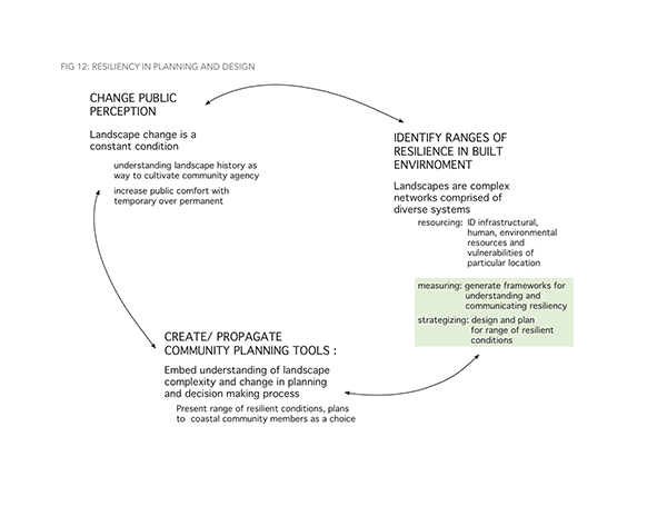
Like the process of increasing resiliency to earthquakes, I propose that the path to climate change resiliency, is three-fold. Unlike the case of earthquakes, however, the path to landscape resiliency begins with public outreach, with cultivating a widespread cultural perception that landscape change is a constant condition. This process is dependent on increasing public understanding of landscape history – in the San Francisco Bay, specifically, that translates to comprehending how the Bay has been filled in over time, how those areas of fill translate to higher risk of shaking from earthquakes and how the fill areas are more prone to inundation from sea level rise over time. Communicating the history of landscape change is a way to cultivate more agency in how we decide and shape its future.
Shifting cultural perception must be coupled with planning and design for varying degrees of resiliency to landscape change. As Jane Amidon describes in her article “Cities, Disturbance and Recovery,” this can be accomplished using two key processes: resourcing and developing frameworks for success. “Resourcing” means identifying infrastructural, human and environmental resources of a particular location. It includes site-specific vulnerabilities to landscape change (impacts of sea level rise and increased storm severity, earthquake epicenters, low-lying infrastructure networks) as well as pressures on or opportunities for growth. “Frameworks for success” means identifying factors by which resiliency can be achieved. This includes explorations on infrastructural robustness and adaptability; increased public health levels; and economic investment. The framework for success would identify a range of resiliency to design and plan for within each area.
The third step in this proposed process is the creation and propagation of community-based planning and design tools. Rather than the top-down approach used by research and planning officials in the case of earthquake resiliency in the San Francisco Bay Area, a more community-based, grassroots approach is an important part of (re)embracing landscape change in our built environment. As note by Wamsler, “Humans have always adapted to environmental changes, including variations in weather and hazards.”11 An important part of her assessment on the topic is that humans have accumulated a more local capacity to adapt, dependent on the cultural influences of a particular locality. It stands to reason, therefore, that decision-making processes on matters of increased resiliency should be focused in large part on the local level. When effectively communicated, identification of vulnerabilities and opportunities for growth at particular sites gives community members greater understanding of the challenges facing them, which in turn allows for greater agency in deciding how to navigate such challenges.